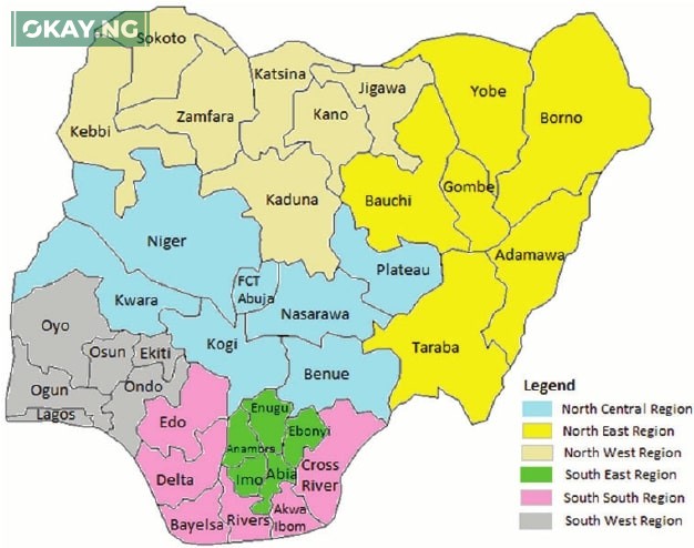
Nigeria’s largest states by landmass shape the country’s agriculture, energy, conservation, and infrastructure planning. With 36 states and the Federal Capital Territory, each region carries a distinct geographic identity and development pathway. Okay.ng reports that understanding land area is crucial for policy, investment, and education.
Why landmass matters
A state’s size influences agricultural potential, natural resource distribution, urban and transport planning, environmental conservation, and tourism growth. Larger states often contain diverse ecosystems, hydropower sites, mineral belts, and room for industrial corridors.
Methodology
- Areas are expressed in square kilometres (km²) and rounded for clarity.
- Ranking covers 36 states only. The FCT (Abuja) is a territory administered by a minister and is not included.
- Capitals and key features are provided to help students and researchers quickly identify each state.
Top 10 Largest States in Nigeria by Landmass
| Rank | State | Area (km²) | Capital | Key features |
|---|---|---|---|---|
| 1 | Niger | 76,363 | Minna | Kainji Dam, Kainji Lake National Park, hydropower corridor |
| 2 | Borno | 70,898 | Maiduguri | Lake Chad Basin, Sambisa Forest, Sahelian rangelands |
| 3 | Taraba | 54,473 | Jalingo | Gashaka Gumti National Park, Mambilla Plateau, highland climate |
| 4 | Bauchi | 49,119 | Bauchi | Yankari National Park, Wikki Warm Springs, savanna woodlands |
| 5 | Kaduna | 46,053 | Kaduna | Nok culture heartland, rail and road hub of the Northwest |
| 6 | Yobe | 45,502 | Damaturu | Dagona Waterfowl Sanctuary, desert-fringe ecosystems |
| 7 | Zamfara | 39,762 | Gusau | Dryland farming, pastoral routes, forest reserves |
| 8 | Adamawa | 36,917 | Yola | Mandara Mountains, Benue valley farmlands, cross-border trade |
| 9 | Kwara | 36,825 | Ilorin | Middle Belt ecology, Asa Dam, gateway between North and South |
| 10 | Kebbi | 36,800 | Birnin Kebbi | Argungu International Fishing Festival, riverine floodplains |
Note: Figures are rounded. Rankings reflect total state land area and exclude the Federal Capital Territory.
Brief profiles of the top five
1) Niger State
Capital: Minna
Why it stands out: Nigeria’s largest state by land area, hosting major hydropower infrastructure at Kainji and expansive protected landscapes around Kainji Lake National Park. Its size enables large-scale agriculture and logistics corridors linking the North and South.
2) Borno State
Capital: Maiduguri
Highlights: Vast Sahel and Sudan savanna zones with the Lake Chad basin shaping agriculture, fisheries, and water management. The state’s landmass contains important wetlands and arid habitats that require careful conservation.
3) Taraba State
Capital: Jalingo
Highlights: Home to Gashaka Gumti National Park and the Mambilla Plateau, Taraba combines the country’s highest elevations with rich biodiversity. The highlands support temperate crops and ecotourism potential.
4) Bauchi State
Capital: Bauchi
Highlights: Yankari National Park anchors Nigeria’s flagship wildlife destination. The state’s large area spans river valleys and woodland savanna with strong tourism and ranching prospects.
5) Kaduna State
Capital: Kaduna
Highlights: A pivotal transport and education hub with deep archaeological links to Nok terracotta culture. Its central location and size make it a strategic site for industrial parks and rail connectivity.
What the ranking means for development
Opportunities
- Agriculture: Room for mechanized farming, grazing reserves, and value chains for grains, legumes, and livestock.
- Energy: Hydropower and transmission routes in river basins, plus solar corridors across the savanna.
- Tourism: National parks, highland plateaus, warm springs, rivers, and cultural festivals.
- Infrastructure: Space for highways, rail spurs, airstrips, inland ports, and industrial estates.
Challenges
- Security and governance: Large territories require robust policing and community engagement.
- Rural services: Electrification, healthcare, and education must reach dispersed settlements.
- Conservation: Parks and woodlands need active protection against habitat loss.
FAQs
How many states are in Nigeria
There are 36 states, plus the Federal Capital Territory which is administered by a minister.
Why is the FCT not ranked
The FCT is a federal territory, not a state, so it is excluded from state-by-state landmass rankings.
Which state is the largest by land area
Niger State is the largest, with about 76,363 km².
Which state is the smallest
By land area, Lagos is the smallest state, though it has Nigeria’s largest urban population.


